| Human Impacts In Hawaii Marine Protected Areas |
| Principal Investigators: Carl Meyer & Kim Holland |
| |
| Project Overview |

Figure 1. Snorkeler stands on the reef, Kealakekua Bay Marine Life Conservation District, Hawaii |
Hawaiian Marine Protected Areas (MPAs) are utilized by hundreds of visitors every day and concern exists that recreation impacts are damaging fragile coral reef habitats at these sites. The most common recreational activities occurring in Hawaiian MPAs (snorkeling and SCUBA diving) are known to damage coral in other geographic regions. During this study, trained observers used waterproofed Global Positioning System (GPS) units to track individual divers and obtain high resolution spatial information on recreation impacts within four Hawaiian MPAs. The goal was to use this novel, empirical approach to obtain a better understanding of the overall usage patterns and mechanisms of human impact at MPA sites, and identify simple strategies for reducing recreation impacts on these areas. |
| |
| Research Questions |
We asked five specific questions about human impacts on MPA reefs:
- How frequently do snorkelers and SCUBA divers touch the reef?
- How often does contact result in broken or damaged coral, or other live substrate?
- Which activity (snorkeling or SCUBA) has the most impact on MPA reefs?
- Do shore-based activities result in more or less reef damage than boat-based activities?
- Can mapping the spatial patterns of recreational activities and reef damage help us reduce human impact in Hawaii MPAs?
The human impact data obtained in this study will help managers to reduce reef damage in heavily-used MPAs. |
| |
| Methods |
| Four MPAs utilized in this study were Honolua-Mokuleia (Maui), Kealakekua Bay (Hawaii), Manele-Hulopoe (Lanai) and Pupukea (Oahu). Each of these sites contain bays that have calm, sheltered conditions for at least part of the year, and a variety of substrates including live coral, coralline algae, uncolonized pavement, volcanic rock, boulders and sand. Fragile corals are found at all four sites but are rare at Pupukea, which is seasonally exposed to high surf. Recreational activities at these sites are dominated by swimming, snorkeling and SCUBA diving, with most visitors gaining access to MPA waters either from the shore or on commercial charter vessels. At each site, researchers equipped with snorkeling gear and a small GPS unit secretly followed and observed individual snorkelers or SCUBA divers. The GPS units were set to automatically log position at 10 sec intervals throughout the track. Observers manually entered GPS waypoints to record locations where people made physical contact with the substrate. Observers used waterproof data sheets concealed on the back of fish identification cards to record information about any substrate contact observed (e.g., type of contact, substrate type and result of contact). |
| |

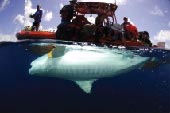
Figure 2. Commercial vessels bring hundreds of snorkelers to Hawaii MPAs every day, yet result in minimal reef trampling. Most reef trampling results from shore-based, 'self-guided' visitors. |

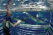
Figure 3. SNUBA divers at Kealakekua Bay. Snorkelers typically float at the surface and have little impact on Hawaii reefs, but SCUBA divers have frequent contact with fragile habitats. |
|
| |
| Results |
| We followed a total of 234 divers (205 snorkelers, 25 SCUBA and 4 SNUBA divers) for a total of 129 h at four MPA sites. Diver tracking revealed that: (1) recreation impacts on coral reef habitats were generally low, (2) SCUBA divers had a greater impact per dive than snorkelers, (3) boat based activities had less impact per dive than shore based activities, and (4) individual behavior was important in determining recreation impacts. Divers made 1,340 substrate contacts within MPA boundaries, but the majority (86%) were with inert substrates (sand and uncolonized rock), hence only 14% were with live substrates (coral, coralline algae and sessile invertebrates). Only nine incidences of obvious substrate damage (0.7% of all substrate contacts) were observed. Only eight (5%) of 153 observed contacts with live coral resulted in visually obvious damage (broken branches or tissue abrasion), of which seven were caused by shore-based snorkelers. Most activities occurred within relatively small, well-defined areas associated with access points. Despite heavy use, recreation impact was low at Hawaiian MPAs because most fragile corals occurred below the maximum depth of the dominant recreational activity (snorkeling). SCUBA diving was only common at one MPA with physically durable benthic habitats (Pupukea MLCD). Access points (shoreline access points or vessel moorings) ‘anchor’ snorkeler and SCUBA diver activity spaces and could be situated to focus recreation impact away from fragile habitats. |
| |
|
| Figure 1. Habitat utilization distribution and substrate contact points for snorkelers and SCUBA divers at Honolua Bay (Honolua-Mokuleia MLCD). Contours indicate probability surfaces for activities; white dashed contour = 95%, white solid contour = 75%, yellow contour = 50%, orange contour = 25%, pink contour = 10%, red contour = 5%. Colored points are diver substrate contact locations; blue points = uncolonized rock, yellow = sand, red = live coral. Red dashed line = MCLD boundary. |
|
| |
| |
| Project Publications |
| Meyer CG, Holland KN (2009) Spatial dynamics and substrate impacts of recreational snorkelers and SCUBA divers in Hawaiian Marine Protected Areas. Journal of Coastal Conservation. 12:209-217 |
| |
| |
|
|