
Mariners and ocean recreationalists in Guam and the Commonwealth of the Northern Mariana Islands will benefit from new high-resolution wave forecasts offered by the Pacific Islands Ocean Observing System (PacIOOS). The new forecasts provide 7.5 days of predicted wave height, period and direction–updated twice per day.
“Mariners, harbor masters, ocean safety officers, swimmers and surfers in the Mariana Islands now have access to high-resolution forecasts to help plan their ocean excursions,” said PacIOOS Director Heather Kerkering. “Wave forecasts can help improve the efficiency of harbor operations and save time and money. But more importantly, better forecasts can save lives.”
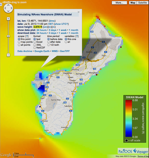
The best way to access the wave forecasts is under the “surf forecast” menu item in the PacIOOS Voyager, a free online mapping platform.
The wave forecasts are delivered using the WaveWatch 3 (WW3) and Simulating Waves Nearshore (SWAN) models, both developed by researchers at the School of Ocean and Earth Science and Technology.
Read the press release to learn more.
About PacIOOS
Based within the School of Ocean and Earth Science and Technology at UH Mānoa, PacIOOS is the Pacific Islands regional component of the U.S. Integrated Ocean Observing System (IOOS®). PacIOOS is a partnership of data providers and users working together to enhance ocean observations and develop, disseminate, evaluate and apply ocean data and information products designed to address the environmental, economic, and public safety needs of stakeholders who call the Pacific Islands home.
