
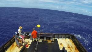
Hawaiʻi now has new ocean and coastal data available to inform weather forecasts and enable safer, more efficient marine transportation. On October 2, 2013, the Pacific Islands Ocean Observing System (PacIOOS), with support from Young Brothers, deployed a bright yellow wave buoy in over 700 feet of water about three nautical miles off Hanalei on the north shore of Kauaʻi.
The buoy measures wave height, wave direction, wave period and sea surface temperature. Scientists say the location off Hanalei is the best point in the main Hawaiian Islands to capture the dominant big swell during winter seasons. Wave buoys stream data to inform safe transit and recreation and provide critical information for coastal hazard and low-lying inundation forecasts for north-facing shores.
“There are active fishing and recreational communities on Kauaʻi that rely on accurate ocean forecasts to know when conditions are safe, and having a wave buoy in this location will improve these forecasts,” explains Heather Kerkering, PacIOOS director. “Data are updated every 30 minutes and broadcast on the National Weather Service’s Marine Weather Channel.”
The buoy joins PacIOOS’ existing network of eleven real-time wave buoys in Hawaiʻi, Guam, the Northern Mariana Islands and the Marshall Islands. Data streams from the buoys to the PacIOOS Voyager, the PacIOOS website and to the Coastal Data Information Program at Scripps Institution of Oceanography. Data streaming is made possible through long-term partnerships involving PacIOOS, U.S. Army Corps of Engineers and Coastal Data Information Program.
More about PacIOOS
Based within the School of Ocean and Earth Science and Technology at the University of Hawaiʻi at Mānoa, PacIOOS is the Pacific Islands regional component of the U.S. Integrated Ocean Observing System (IOOS®). PacIOOS is a partnership of data providers and users working together to enhance ocean observations and develop, disseminate, evaluate and apply ocean data and information products designed to address the environmental, economic and public safety needs of stakeholders who call the Pacific Islands home.
