
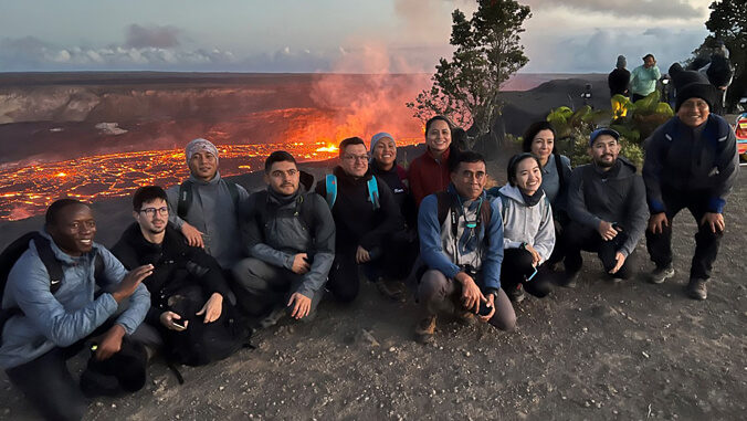
On June 3, for the first time since 2019, the international volcanology training course hosted by the Center for the Study of Active Volcanoes (CSAV) at the University of Hawaiʻi at Hilo, welcomed a class of 12 participants from around the world.
The eight-week summer course is designed to assist volcanologists and technicians from developing nations in attaining self-sufficiency in monitoring volcanoes. The field training on Hawaiʻi Island and in Vancouver, Washington, emphasizes volcano monitoring methods, both data collection and interpretation, in use by the U.S. Geological Survey (USGS). The participants also learn proper use and maintenance of volcano monitoring instruments.
The program was initiated in 1991 as a collaborative effort among the UH Hilo Geology Department, the Hawaiʻi Institute of Geophysics and Planetology (HIGP) at UH Mānoa, and the USGS Hawaiian Volcano Observatory. More than 30 individuals will be contributing to the course this year, with instruction provided by HIGP and UH Mānoa Department of Earth Sciences faculty, and current and retired USGS staff from the Hawaiian Volcano Observatory, Cascades Volcano Observatory and Alaska Volcano Observatory.
“Hawaiian volcanoes are among the most active in the world, but unlike violently explosive volcanoes, they can be approached and studied without significant risk,” said Don Thomas, director of CSAV and faculty member at HIGP in the UH Mānoa School of Ocean and Earth Science and Technology. “As a result, the course and Hawaiʻi Island provide the ideal environment for practicing volcano monitoring techniques.”
Monitoring, analyzing and interpreting data
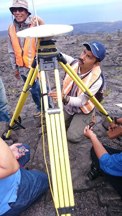
The curriculum covers available monitoring technology, but emphasizes technology that is accessible to the volcano observatories in participants’ home countries. Attendees learn to properly install seismic stations, precision GPS stations and tiltmeters; and analyze and interpret data from those types of equipment. They also practice monitoring and interpreting the chemistry of volcanic gas emissions; mapping lava flows and explosive deposits, and interpreting those maps in the context of eruption magnitude and risk; and assessing satellite remote sensing and thermal imagery.
“We also provide training on crisis management during a volcanic crisis: how to interact with the media during a crisis, how to educate the general public about volcanic hazards, and how to respond during a volcanic crisis,” said Thomas. “With this focus on forecasting and rapid response, we really aim to bolster volcano observatories around the world in their efforts to save lives and property.”
Connecting colleagues around the world
Since 1991, 264 scientists and technicians from 30 countries have participated in the training program. Most attendees have been funded through the USGS Volcano Disaster Assistance Program with funding from USAID. The vast majority of participants are volcanologists or technicians actively monitoring volcanoes in their home countries. A typical cohort consists of trainees from five or six different countries, providing a valuable opportunity for international practitioners focused on volcanic hazards to connect.
“As the cohort progresses through the training program, they become colleagues with similar interests, work objectives and common challenges in fulfilling their volcano monitoring roles,” said Thomas. “After they return home, they have a network of colleagues that they can call on for help in problem-solving and brainstorming and dealing with the inevitable challenges that they’ll face in dealing with their home volcanoes.”
—By Marcie Grabowski
