New interactive website provides digital rainfall maps, patterns
University of Hawaiʻi at MānoaContact:
Posted: Oct 20, 2011
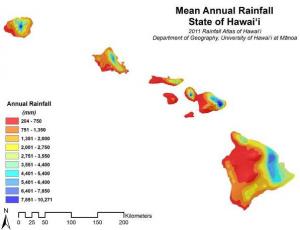
The Hawaiian Islands have one of the most diverse rainfall patterns on earth. One of the most frequently cited publication on Hawai‘i’s environment is the Rainfall Atlas of Hawai‘i, first published in 1986, by UH Mānoa Geography Professor Dr. Tom Giambelluca, Meteorology Professor Tom Schroeder and Michael Nullet, currently a Geography Research Assistant. The printed publication provided a set of maps of the spatial patterns of rainfall for the major Hawaiian Islands. Fast forward twenty-five years, Giambelluca, along with UH Mānoa Geography Assistant Professor Qi Chen and Masters' student Abby Frazier, recently led a team of UH Mānoa researchers to create a new, interactive online website housing updated rainfall patterns. Giambelluca specializes in climate, climate change, and ecohydrology.
The website was developed to make rainfall maps, data and related information easily accessible. Features include: high resolution downloadable digital maps for mean monthly and annual rainfall and uncertainty for each station used in the analysis, as well as files with information on each rain gage station.
The website also allows users to view the patterns of mean monthly and annual rainfall and corresponding uncertainty, zoom in on areas of particular interest, navigate to specific locations with the help of a choice of different base maps, and click on any location to get the mean annual rainfall and a graph and table of mean monthly rainfall.
Over the course of the two-year project, rainfall measurements taken at over 1,000 stations were used as the principal source of information in the development of the rainfall maps. The maps represent the best estimates of the mean rainfall for the 30-year base period 1978–2007. However, for many reasons, it is not possible to determine the exact value of mean rainfall for any location. Therefore, for every map of mean rainfall, corresponding map of uncertainty is provided.
Knowledge of the mean rainfall patterns is critically important for a variety of meteorological, agricultural and resource management issues, including ground water and surface water development and protection, controlling and eradicating invasive species, protecting and restoring native ecosystems, and planning for the effects of global warming.
The 2011 Rainfall Atlas of Hawai‘i was developed under an agreement between the State of Hawai‘iCommission on Water Resource Management and the U.S. Army Corps of Engineers, Honolulu District under Section 22 of the Water Resources Development Act of 1974. Contract No. W9128A-04-D-0019, Contract Task Order No. 0038 was awarded to Wil Chee Planning Inc., which subcontracted the work to the University of Hawai‘i at Mānoa, Geography Department.
To access the website, visit: http://rainfall.geography.hawaii.edu/.

