
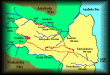
Another important program of the Hawaii Stream Research Center is the further development of a PC ARC-Info based Geographical Information System which is housed within the Center for Conservation Research and Training at UH. The GIS, as it is commonly called, allows for the integration of graphical data layers such as maps, which allow for the visualization of topography or land-use data, with numerical data such as the number of native species counted in a particular area or the inches of rainfall collected in a particular rain qauge. Through the use of Global Positioning Systems, we are able to locate to within a few meters the ground locations of data collection positions. Video tapes of survey sites, photos of structures or species, and even satellite imagery will eventually attached to the data layers and accessible through our GIS. Our long-range goal is to provide for desktop access by resource managers to our GIS so that they can better utilize the rapidly expanding array of information and thus more cost-efficiently and effectively manage Hawaii's resources. We continue to expand and refine the HSRC internet website to facilitate information exchange with the broader scientific community and the general public. In this way, we hope to encourage international participation in our efforts to conserve and sustain the natural resources that make Hawaii so unique and special.
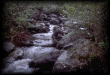
 | GIS Applications: Some examples of GIS applications in stream survey, inventory and analysis are presented here. Click on the image on left to access these. |
| 
| 
| 
| 
| 
|
