HaleNet Climate Network
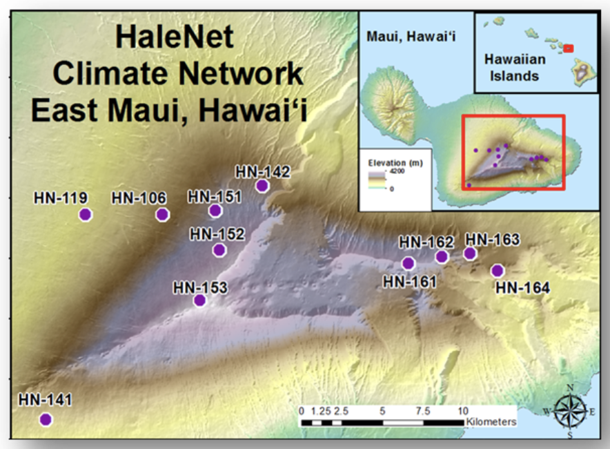
In June of 1988 the beginnings of the HaleNet climate network were established on the leeward slopes of Haleakalā Volcano with the installation of three climate measurement stations (Figure 1). Two climate monitoring stations were collocated with MauiNet sites HN-119 (960 m) and HN106 (1640 m) and a third station HN-151 (2120 m ) was installed near the Haleakalā National Park Headquarters (Figure 1). This leeward transect of HaleNet stations was expanded further upslope in March 1990 with the addition of HN-152 (2590 m) and a summit station HN-153 (2990 m). In June 1992, stations HN-164 (1650 m), HN-163(1960 m), HN-162(2260 m) and HN161(2460 m) were installed along a second elevation transect located on the windward side of the island. These windward stations are all located in remote areas, making access to them difficult without the aid of helicopter transportation. In December 2000, an additional leeward station (HN-141) was installed at 1240 m elevation on the southwest rift of Haleakalā Volcano. In August 2001, a windward station (HN-142) was installed in The Nature Conservancy Waikamoi Preserve located in the upper Pi‘ina‘au stream drainage basin at 1932 m. The Nakula station on the south-facing slope of Haleakala, HN-143 (1645 m), was added in 2016. Of the twelve stations that once operated in the HaleNet climate network, nine are still in full operation. The Waikamoi station (HN-142), which was installed for a research project on cloud water interception, was removed in August 2003. The Horseshoe Pu`u station (HN-163) at 1960 m elevation was discontinued after being badly damaged by lightning and high winds in 1996. The Pu`u Pahu station (HN-106) at 1650 m elevation was vandalized in 2003 and now only collects rainfall data. The entire network has a vertical coverage of 810 m (1650 – 2460 m) and 2030 m (960 – 2990 m) along the windward and leeward slopes respectively.
HavoNet
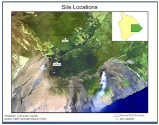
In 2005 and 2006, two field sites were established within Hawai‘i Volcanoes National Park (HavoNet) representing native forest and a forest invaded by an alien tree species, both within the cloud zone on the slopes of Kilauea Volcano on Hawai‘i Island (Figure 2). These sites are equipped with an extensive array of instruments as well as eddy covariance sensors to monitor energy exchange and fluxes of water vapor and carbon dioxide between the atmosphere and the ecosystem.
Little HaleNet
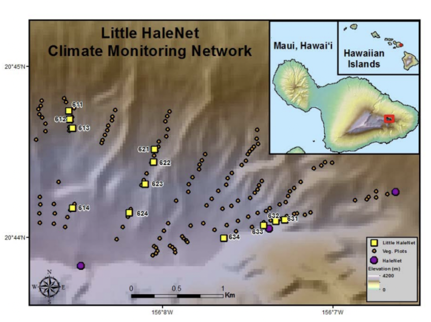
In August of 2005, a network of 12 climate stations was established to extend westward from HaleNet and to integrate with 134 permanent vegetation plots established on the northeast slope of Haleakalā Volcano (Figure 4). The climate stations (referred to as “Little HaleNet”) range in elevation from ~1980 m to ~ 2315 m and are positioned along three elevational transects from the Northeast Rift to Pu‘u Alaea. Each transect consists of one station in the alpine grassland and three stations that bracket the upper cloud forest limit. The climate stations are equipped with a range of instrumentation and vegetation plots are arranged along nine elevational transects representing points within the upper ~300 m of cloud forest and ~ 300 m immediately above the forest line. This network is currently being operated and managed by the Resource Management team at Haleakalā National Park.
HIPPNET
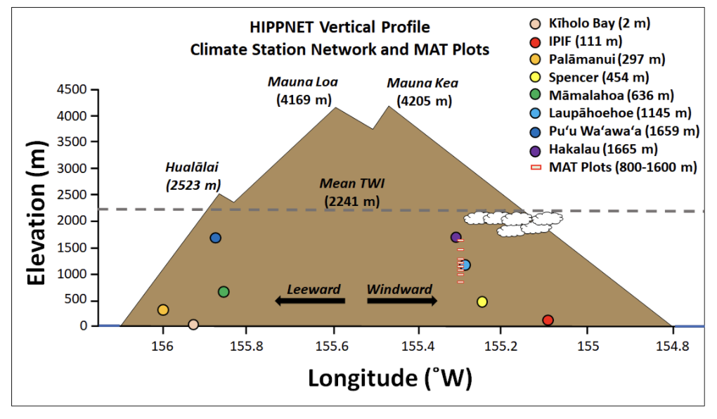
The Hawai‘i Island Permanent Plot Network (HIPPNET) is a partnership between the USDA Forest Service Pacific Southwest Research Station, Institute of Pacific Islands Forestry, the University of Hawai‘i at Hilo, the University of Hawai‘i at Mānoa, and the University of California at Los Angeles. A total of eight HIPPNET climate stations were established, all on Hawai‘i Island, seven of which are currently in operation (Figure 4). These stations have been collecting climate data since 2009 and include a range of measurements. Two of the HIPPNET sites are tower-mounted stations in forest ecosystems and four of the stations have been established to complement permanent vegetation plots associated with the Center for Tropical Forest Science permanent plot network (http://ctfs.si.edu/).
CraterNet
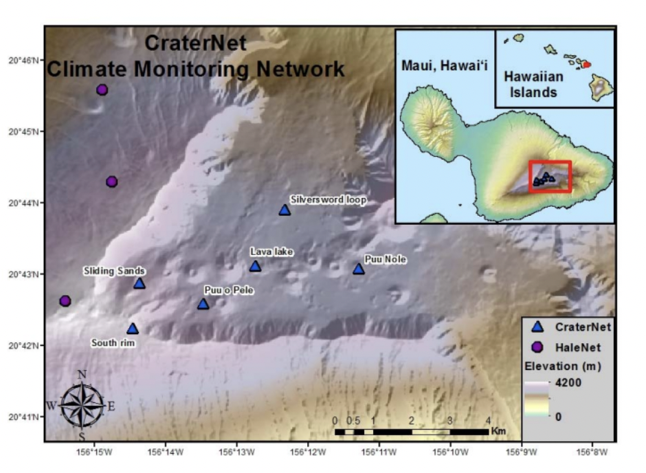
CraterNet consists of 13 weather stations located in Haleakalā crater as part of an effort to monitor endemic plant and insect species at high elevations (Figure 6). This network began operating in July of 2010 and spans an elevation gradient of 971 m (1927 to 2898 m), encompassing the major geographic range of the current Haleakalā silversword (Argyroxiphium sandwicense subsp. macrocephalum), an iconic, threatened plant species endemic to the upper portion of Haleakalā. Station locations were chosen based on population density of the silversword and proximity to existing or planned silversword research plots. CraterNet was established by and is currently maintained by the project PI at the University of Hawai‘i Mānoa Department of Plant and Environmental Protection Sciences (PEPS).
Hawai‘i MesoNet
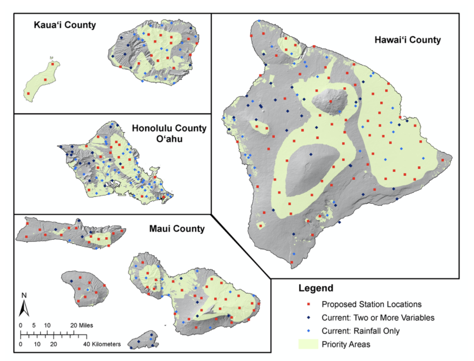
In September of 2021, the National Science Foundation (NSF) awarded researchers from the University of Hawai‘i at Manoa, a 3-year, $1.33M grant to deploy dozens of climate stations across the state. These new climate stations will be combined with existing station networks (described above), as well as other ongoing projects to establish a world class climate monitoring system. (Figure 7). “Hawai‘i MesoNet” is a public impact research project to better understand and forecast the complex weather and climate of the Hawaiian Islands.
Other Networks
- ESRL/GMD Mauna Loa Observatory (MLO) is a premier atmospheric research facility that has been continuously monitoring and collecting data related to atmospheric change since the 1950’s.
- The Remote Automated Weather Stations (RAWS) were established and are maintained by the National Interagency Fire Center. RAWS stations are located across the US, the US territories of Puerto Rico and St. Croix in the Caribbean, and on several islands in the Pacific.
- The Soil Climate Analysis Network (SCAN) program was established by the Natural Resources Conservation Service (NRCS).
- The Automated Surface Observing Systems (ASOS) program is a joint effort of the National Weather Service (NWS), the Federal Aviation Administration (FAA).
- The National Weather Service Cooperative Observer Program (COOP) which is an international program that comprises more than 10,000 volunteers who take observations on farms, in urban areas, suburban areas, National Parks, seashores and mountain tops in the US and at least 28 other non-US territories.
- The Community Collaborative Rain, Hail & Snow Network (CoCoRaHs) is a grassroots volunteer network of backyard weather observers working together to measure and map precipitation (rain, hail and snow) in their local communities.
See Longman et al 2019 for a more detailed description of these and all of the networks mentioned on this page