Is your research missing? Email hcdp@hawaii.edu or fill out our Google Form
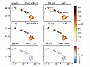
- Mapping Daily Air Temperature Over the Hawaiian Islands From 1990 to 2021 via an Optimized Piecewise Linear Regression Technique
 Contributed by Dr. Keri Kodama View the full paper at: https://doi.org/10.1029/2023EA002851 A new paper on mapping daily air temperature was recently published by Dr. Keri Kodama, an East-West Center Fellow … Read more
 - Deriving gridded hourly rainfall on Oʻahu by combining gauge network and radar rainfall
 Contributed by Dr. Yu-Fen Huang. If you have any questions regarding the paper, please contact Dr. Yu-Fen Huang (yfhuang@hawaii.edu) and Dr. Yinphan Tsang (tsangy@hawaii.edu). Accurately estimating precipitation in Hawaiʻi presents a … Read more
 - A Century of Drought in Hawai‘i
 Contributed by Abby Frazier (abbyf@hawaii.edu) Drought is a regular and natural component of the climate in Hawaiʻi with severe effects across many sectors statewide. This paper provides a comprehensive synthesis … Read more
 - Climate change impacts shifting landscape of the dairy industry in Hawai‘i
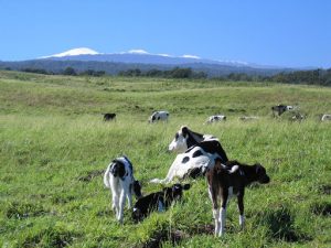 Photo credit: Dr. C.N. Lee Contributed by Mandeep Adhikari: mandeep@hawaii.edu Future projections indicated that air temperature would increase 1.3 to 1.8 °C by mid-century and 1.6 to 3.2 °C by the … Read more
 - Diagnosing Hawai‘i’s Recent Drought
 Contributed by Henry Diaz (hfdiaz@hawaii.edu) Read the full article: https://journals.ametsoc.org/view/journals/clim/35/13/JCLI-D-21-0754.1.xml Hawai‘i’s recent drought is among the most severe on record. Wet-season (November-April) rainfall deficits during 2010–2019 rank second lowest among … Read more
 - Follow the Drop mobile app and data platform
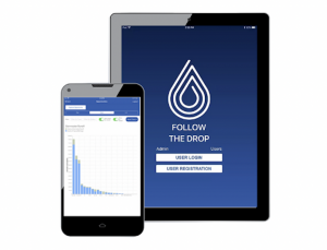 Follow the Drop is a mobile app and data platform that supports municipal green stormwater infrastructure planning and incentive programs. It is currently be used by the City and County … Read more
 - Optimizing Automated Kriging to Improve Spatial Interpolation of Monthly Rainfall over Complex Terrain
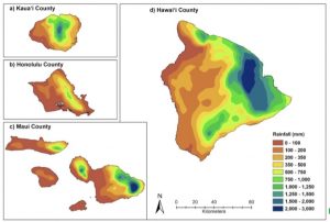 Mapping rainfall over the complex topography of Hawai‘i is not easy. It’s difficult to produce a good quality map that captures the extreme gradients and spatial variability of rainfall in … Read more
 - Climate Adaptation for Tropical Island Land Stewardship: Adapting a Workshop Planning Process to Hawai‘i
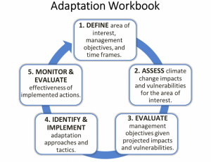 Read the full article by Longman et al. here Tropical island ecosystems are highly vulnerable to the multiple threats of climate change (Nurse et al. 2014; Bonan 2008). In response, … Read more
 - Developing a real time tool to identify the likelihood of avian malaria insitu development to help the targeting of mosquito control efforts
 Contributed by Lucas Fortini: (lfortini@usgs.gov). Contact for more info. Avian malaria poses the threat of extinction to multiple unique Hawaiian forest bird species. With mosquito vector control as one of … Read more
 - Understanding the environmental factors determining the spatial patterns of malaria prevalence in native forest birds across Hawaii
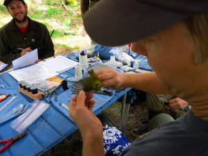 Contributed by Lucas Fortini The clearly identified link between temperature and avian malaria across the landscape threatens several unique native Hawaiian birds with extinction as the climate warms. With the … Read more
 - Restoring people and productivity to Puanui: challenges and opportunities in the restoration of an intensive rain-fed Hawaiian field system
 “Prior to European contact, Hawaiian cultivators developed and sustained large rain-fed field systems based on sweet potato (Ipomoea batatas) and other crops. However, these intensive systems largely were abandoned in … Read more
 - Hawaiʻi Groundwater Recharge Tool
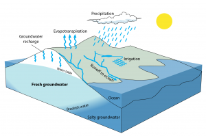 Use the tool here. “The primary source of freshwater to Hawai‘i’s groundwater systems is recharge. Accurate estimates of recharge are critical for groundwater-resource management and planning. The Hawai‘i Groundwater Recharge Tool allows … Read more
 - Dynamical downscaling of near-term (2026-2035) climate variability and change for the main Hawaiian Islands
 Contributed by Katrina M. Fandrich (kfandrich@albany.edu) This study presents results from an ensemble of regional climate model simulations (periods 1996–2005 and 2026–2035) that are used to examine the effects of … Read more
 - Methodological Intercomparisons of Station-Based Gridded Meteorological Products
 To learn more, read: Methodological Intercomparisons of Station-Based Gridded Meteorological Products: Utility, Limitations, and Paths Forward by Newman et al. This study presents a gridded meteorology intercomparison using the State … Read more
 - Little HaleNet
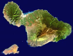
 To learn more, read Climatology of Haleakalā by Ryan Longman or visit: https://sites.google.com/a/hawaii.edu/ecohydrology_lab/current-research/little-halenet The high-elevation northeastern slopes of Haleakalā Volcano are home to some of the most remote and undisturbed … Read more
 - Pacific Island Mangrove Monitoring Network (PACMAN)
 Contributed by Rich MacKenzie (richard.mackenzie@usda.gov) Sea-level rise (SLR) is the greatest future threat that intact Pacific island mangroves face. The loss of mangroves on Pacific Islands will have huge consequences … Read more
 - Cloud Water Interception in Hawaii
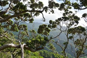
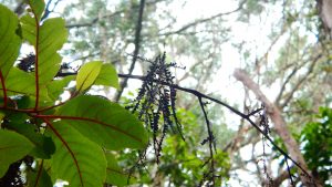
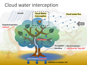 Contributed by Han Tseng (tsenghan@hawaii.edu) Cloud water interception (CWI), the passive capturing of fog water by plants, is a unique ecohydrological process in tropical montane cloud forests that have long … Read more
 - Auwahi Dry-land Forest Restoration Project
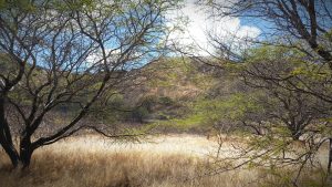
 The Hawaiian dryland montane forest is considered one of the most biologically diverse ecosystems in the islands; however less than 10% of Hawai‘i’s original dry land forest remains (Medeiros and … Read more
 - Aloha+ Challenge
 Hawaiʻi Local2030 Hub through public-private partnerships works to provide data and track progress on the Aloha+ Challenge, a statewide commitment to achieve Hawaiʻi’s local Sustainable Development Goals (SDGs) that are … Read more
 - Sea-level rise drives wastewater leakage to coastal waters and storm drains
 Contributed by Trista McKenzie While sea-level rise (SLR) is frequently associated with surficial flooding and beach erosion, its impact to groundwater is also important. SLR can lead to rising groundwater … Read more
 - Climate Monitoring In Hawaii
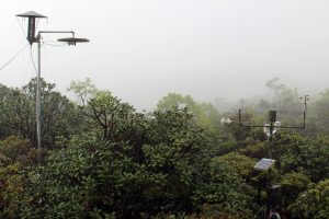
 Contributed by Ryan Longman at rlongman@hawaii,edu Long-term, accurate observations of atmospheric phenomena are essential for a myriad of applications, including historic and future climate assessments, resource management, and infrastructure planning. … Read more
 - Hawaiian summer rainfall: Two distinguishing variability regimes
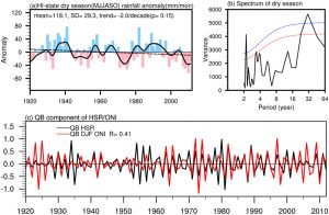 Contributed by Xiao Luo: luoxiao.rf@gmail.com Surrounded by the subtropical Pacific Ocean and immersed in persistent trade winds, the Hawaiian Islands experience distinct seasonality in rainfall: a wet winter from November … Read more
 - UH SLC Sea Level Forecasts
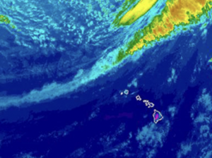
 The University of Hawaii’s Sea Level Center provides a product for sea level forecasts. The product provides an outlook of monthly sea level anomalies for the next one to two … Read more
 - Fire and Rain: The Legacy of Hurricane Lane in Hawaiʻi
 By Alison D. Nugent, Ryan J. Longman, Clay Trauernicht, Mathew P. Lucas, Henry F. Diaz, and Thomas W. Giambelluca. Click here to read the publication. “Hurricane Lane, which struck the … Read more
 - Temperature trends in Hawaiʻi: A century of change, 1917–2016
 Contributed by Marie Mckenzie Based on a revised and extended multi-station Hawaiʻi Temperature Index (HTI), mean air temperature in the Hawaiian Islands has warmed significantly (p = 0.0007) at 0.05°C/decade … Read more
 - The Soil Climate Analysis Network (SCAN)
 The Soil Climate Analysis Network (SCAN) program was established by the Natural Resources Conservation Service (NRCS). SCAN stations monitor and report hourly measurements of RF, Ta, RH, WS, SM, Ts and … Read more
 - Volcanic Aerosol Impacts on Hawaii Island Rainfall
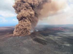 Contributed by Tianqi Zuo The aerosol emissions from Kilauea volcano are affecting Hawai’i rainfall locally. Based on the analyses from 2014-2017, the days with high emissions have on average 8 mm/day … Read more
 - Mauna Loa Observatory – ESRL Global Monitoring Laboratory
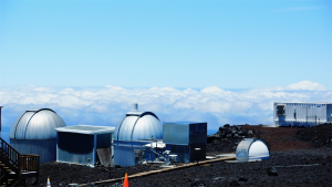 The Mauna Loa Observatory (MLO) is an atmospheric baseline station of the Global Monitoring Laboratory (GML), of the National Oceanic and Atmospheric Administration (NOAA). The mission of ESRL is to measure atmospheric … Read more
 - Pacific Drought Knowledge Exchange
 Climate change, climate variability, and drought (CCVD) will exert a growing impact on landscapes, watersheds, and nearshore areas in the Pacific Islands. Droughts in the Pacific Islands can be extremely … Read more
 - Drought and wildfire at Hawai‘i Volcanoes National Park
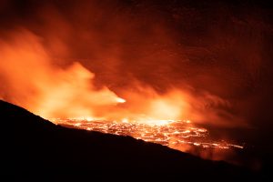 During the 2002–2003 drought, relative humidity values dropped into the single digits, and wildfire spread into “safe areas” of Hawai‘i Volcanoes National Park, including wet forests, with tree ferns (Cibotium … Read more
 - HavoNet
 Two field sites are located within Hawai‘i Volcanoes National Park (HavoNet) representing native forest and a forest invaded by an alien tree species, both within the cloud zone on the … Read more
 - Remote Automated Weather Stations (RAWS)
 Remote Automated Weather Stations (RAWS) are weather stations set up on tripods, and they look like little “Lunar Landers.” The data collected from these stations are used in numerous applications, … Read more
 - CraterNet
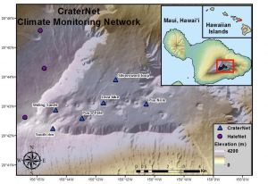 CraterNet consists of 13 weather stations located in Haleakalā crater (a large erosional depression near the summit) as part of an effort to monitor endemic plant and insect species at … Read more
 - Long-Term, Gridded Standardized Precipitation Index for Hawai‘i
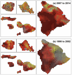
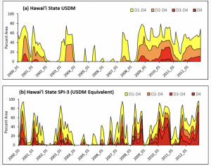 Percent area drought time series (2000–2012) for the State of Hawai‘i for: (a) monthly aggregated U.S. Drought Monitor; and (b) gridded SPI-3 converted to USDM categories. Click here to read … Read more
 - Drought effects on drinking water supply on Maui
 Reduced rainfall from meteorological drought can have direct effects on social-ecological systems; the most obvious consequence is reduced runoff and streamflow. Streams provide important ecological services on tropical islands, including … Read more
 - The Hawai’i Permanent Plot Network
 The Hawai’i Permanent Plot Network (HIPPNET) was initiated in 2007 by faculty and research ecologists at the University of Hawaii, USDA Forest Service, and UCLA to investigate forest dynamics across … Read more
 - Disturbance Driven Rainfall on O‘ahu
 This research explores the relationship between 4-types of atmospheric disturbances and their contributions to daily rainfall on O‘ahu Hawai‘i. On average, atmospheric disturbances account for 29% of the annual and 41% of the seasonal (Nov – April) rainfall on O‘ahu Hawai‘i. Cold, fronts are the most common disturbance type, and fronts that cross over the island are shown to bring significantly more rainfall than the fronts that track to the north of the Island chain…
 - Haleakalā Climate Network
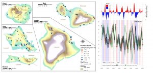
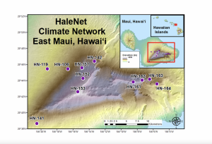 The Haleakalā Climate Network consists of two transects of climate stations along the leeward and windward slopes of Haleakalā Volcano, Maui Island, Hawai‘i. The upper elevation stations are within Haleakalā National Park. HaleNet was established in 1988-90 on the relatively dry west-northwest facing (leeward) slope. The first stations were established in June 1988 at elevations of 960, 1640, and 2120 m…
 - Protecting Endangered Snail Populations
 Contributed by John DeLay Monitoring the current endangered snail population and the new snail enclosure at the summit built in anticipation of climate change and the other using AI to detect … Read more
 - Using Statistics to Select Atmospheric Predictor Variables
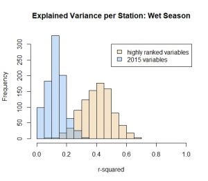 An exploratory analysis found that atmospheric predictor variables selected through statistical methods can lead to more accurate rainfall projections when compared to the previous predictor set used in statistical downscaling for rainfall projections in Hawaiʻi. This figure shows the skill of a linear model in projecting rainfall…
 - Shifting Streamflow Extremes
 In Hawaiʻi, the maximum streamflow in a year was not always the result of the maximum rainfall, based on analyses from 1975 to 2005. The timing of both maximum events has shifted from early Jan to late Dec, likely due to the changes in ENSO…
 - Rainfall and Cloud Water Monitoring on Mt. Kaʻala
 The Natural Area Reserve at the summit of Mt. Kaʻala on the island of Oʻahu serves as a refugia for native biodiversity and is of special ecohydrological significance as the forest captures water directly from passing clouds…