Hawai‘i Mesonet
Hawai‘i Mesonet Live Data Access
What is the Hawaiʻi Mesonet and why is it needed?
The Hawaiʻi Mesonet is a statewide advanced weather and climate monitoring network of approximately 100 telemetered stations, now under construction.
Hawaiʻi is one of only 20 states that has not had a statewide Mesonet until now. While climate information has been gathered for over 100 years by various entities in the islands, the climate observing network in Hawai‘i is fragmented, unmanaged, declining in spatial coverage, and inadequate to meet the needs of researchers and the many stakeholders dependent on the data and the research the data supports. Until recent decades, the mainstay of the climate observing network consisted of stations operated by the sugarcane and pineapple industries. With the contraction and eventual cessation of large-scale agriculture in the islands, many stations were discontinued.
Do we need so many stations?
The Hawaiian Islands experience extreme spatial diversity of temperature, rainfall (average rainfall ranges from 8 to 400 inches/year), cloud cover, solar radiation, wind, humidity, and other variables driven by complex topography, varied wind patterns, and a persistent inversion layer known as the trade wind inversion (TWI). Rainfall gradients are among the steepest found anywhere on Earth; in West Maui, for example, average annual rainfall differs by more than 140 inches over a distance of 1 mile. To adequately monitor weather and climate requires a dense and well distributed network of stations.

Who pays for building it?
More than $1.5M for the purchase of equipment was obtained primarily from the National Science Foundation, with additional funds provided by the Hawaiʻi Commission on Water Resources Management and the Honolulu Board of Water Supply. Support for the costs of installation come from the Water Resources Research Center and the Office of the Vice Provost for Research and Scholarship at the University of Hawaiʻi at Mānoa.
How can we ensure that the Hawaiʻi Mesonet continues to operate for decades?
The cost of operating and maintaining the Hawaiʻi Mesonet and managing and making the data available is estimated to be around $500K per year. Around 40-50% of that amount will be derived from the National Mesonet program. The remaining funding will have to come from state, county, and private sources.

Who needs the data?
Data from the Hawaiʻi Mesonet is vitally important for a wide range of different uses, including weather forecasting, flood warning, fire warning, emergency management, water resource management, agriculture, ranching, cultural resource protection, ecosystem protection, recreation, research on weather, climate, hydrological processes, ecosystem processes, and many other topics.
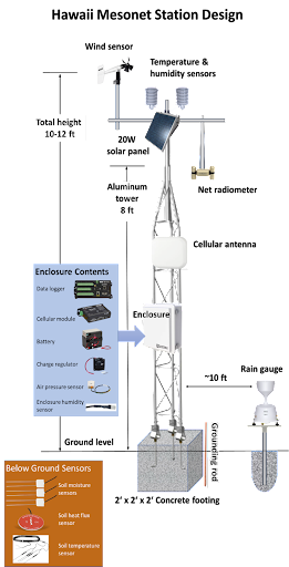
What does each station measure?
Each Mesonet station measures a full array of variables needed for weather forecasting, emergency management, water resource management, agriculture, and many other applications. Each sensor is scanned every 4 seconds, and averages and other statistics are recorded every 5 minutes. All stations transmit their data to us every 15 minutes to provide real-time information from throughout the state. Measurements include: rainfall, air temperature, relative humidity, wind speed and direction, air pressure, solar radiation, reflected solar radiation, incoming and outgoing longwave radiation, net radiation, soil heat conduction, soil temperature at three depths, and soil moisture at three depths.