
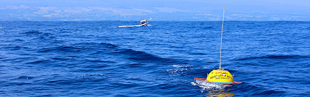
The Pacific Islands Ocean Observing System (PacIOOS) performed routine maintenance of the Hilo Bay wave buoy and retrieved harmful gear that was wrapped around the mooring line. In order to keep the buoy operational, ocean users are kindly asked to carefully navigate around the wave buoy, refrain from tying to the equipment and avoid fishing within 600 yards to minimize entanglement in the mooring line.
The buoy is located more than 7 miles northeast of Hilo harbor and will continue to send information on ocean and wave conditions. It is part of the existing PacIOOS network of 13 real-time wave buoys across the Pacific, providing data on wave height, direction, period and sea surface temperature.
- Buoy Mooring Location: 19° 46.89’ N, 154° 58.08’ W; 188 fathoms depth
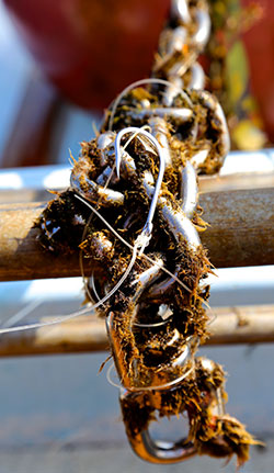
“The wave buoys, and the sensors that lie within, are very sensitive. Any sort of collision or other abrupt impact can damage the instruments,” says Kimball Millikan, PacIOOS marine research engineer. “When we perform check-ups, we sometimes find fishing line or other marine debris around the mooring line which can, worst case, cut the buoy free.”
Wave buoy data benefit the entire community and are important to make well-informed and safe decisions. Ocean users, including fishermen, commercial operators, surfers, paddlers and swimmers, can access all ocean data online, free of any charge. Real-time wave data are also vital to prepare the community, emergency responders, and county officials for big wave events that could potentially impact Hilo’s shoreline.
Data streaming for the PacIOOS wave buoy is made possible through long-term partnerships between PacIOOS, the U.S. Army Corps of Engineers and Coastal Data Information Program.
—By Kapiʻolani Ching
