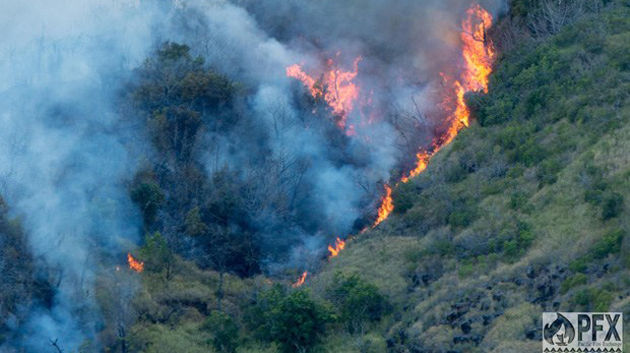

A new research paper co-authored by University of Hawaiʻi at Mānoa researchers outlines the surprising frequency of wildfire in the Hawaiian Islands. Clay Trauernicht and Creighton Litton of the Department of Natural Resources and Environmental Management in the College of Tropical Agriculture and Human Resources drew on multiple sources to construct a 108-year fire history that demonstrates a more-than-fourfold increase in the area burned annually statewide in recent decades.
“People don’t typically think of wildfire as a frequent disturbance on tropical islands,” said Trauernicht. However, it is a serious threat to communities, watersheds and other natural resources in Hawaiʻi, a fact that has long been known to environmental managers. Now that threat has been quantified.
The paper, published in Pacific Science, found that within the last decade the state has experienced an average of more than 1,000 fires burning over 20,000 acres each year. Relative to total land area, the percentage of Hawaiʻi that burned annually from 2005 to 2011 was comparable to, and in some years exceeded, that of the western United States.
Human activity increases “flammability”
The researchers also looked at the spatial patterns of recent fire incident records to understand the factors causing these fires. The frequency of ignitions was highest in developed areas, pointing to the fact that over 99 percent of known wildfire causes in Hawaiʻi are due to human activities, unlike many parts of the mainland, where lightning is an important contributing factor.
The authors showed that human activities have also dramatically increased the “flammability” of Hawaiʻi’s landscapes through land-use practices that have promoted the spread and establishment of fire-prone, nonnative grasses. This includes the introduction of these species for pastures and as ornamental plants, a legacy of deforestation for ranching and plantations, and, most recently, the widespread abandonment of agricultural lands. They used historical records and U.S. Department of Agriculture census data to show that the land area under active grazing or cultivation occupied approximately 2.6 million acres, more than half of Hawaiʻi’s total land area, in 1960, but has since declined to only 970,000 acres, a reduction of more than 60 percent.

Not only are these fallow lands reverting to vast expanses of fire-prone vegetation, but agricultural producers historically provided critical support to fire response agencies in the form of road maintenance, water access and equipment such as bulldozers, support that is no longer available when these lands are not under agricultural production.
Other risk factors include strong rain shadow effects in the leeward areas and episodic droughts, especially those associated with El Niño events such as are happening now, creating year-round potential for frequent and often destructive wildfires. Not only is there a heightened risk of wildfire, but its potential impacts may be more acute in the islands, given the small land area, tight linkages between terrestrial and marine ecosystems and sensitivity of native ecosystems to disturbance.
Wildfire management
On a more positive note, the researchers emphasize that since the links between wildfire and human activities are so strong in Hawaiʻi, there are far more ways that humans can cut down on the possibility of wildfire by changing those activities. They point to clear pathways to address the issue through public outreach and engagement and landscape-scale approaches to watershed management.
There is another possible benefit: “Given the increasing threat of wildfire to communities and resources, and its disregard for property lines, wildfire management provides an opportunity to bring together diverse interests and stakeholders to work towards a common goal,” said Trauernicht.
—A College of Tropical Agriculture and Human Resources news release

