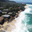
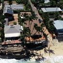
More extreme erosion projected for Oʻahu’s shores
To create erosion predictions, the team of researchers used a computer model that incorporates about 30 years of satellite imagery, as well as aerial and drone imagery.


To create erosion predictions, the team of researchers used a computer model that incorporates about 30 years of satellite imagery, as well as aerial and drone imagery.
The $1 million will focus on the area between Sunset Beach and Sharks Cove.

Eleven projects were awarded a total of $2.3 million in the 4th UH Mānoa Strategic Investment Initiative competition.
A new interactive mapping tool created by researchers at PacIOOS provides West Maui with predictions of coastal flooding.

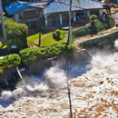
Participants witnessed the impacts of climate change on Oʻahu’s North Shore and Māpunapuna.
Researchers assessed the shoreline around Oʻahu most vulnerable to erosion under three scenarios of sea-level rise—all estimated to occur before, and shortly after mid-century.
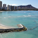
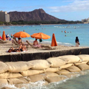
Replacing the Royal Hawaiian groin is the first of many beach improvement projects planned for the next several years.

Sea level variability alters tidal cycles and enhances the risks of coastal flooding and erosion beyond changes associated with sea level rise.

The research uses historic aerial photos, current drone imagery and topographic surveys to document the changes and provide information for policymaker development plans.
The program under the School of Ocean and Earth Science and Technology and the Department of Economics issues an alarming report on beach erosion.
