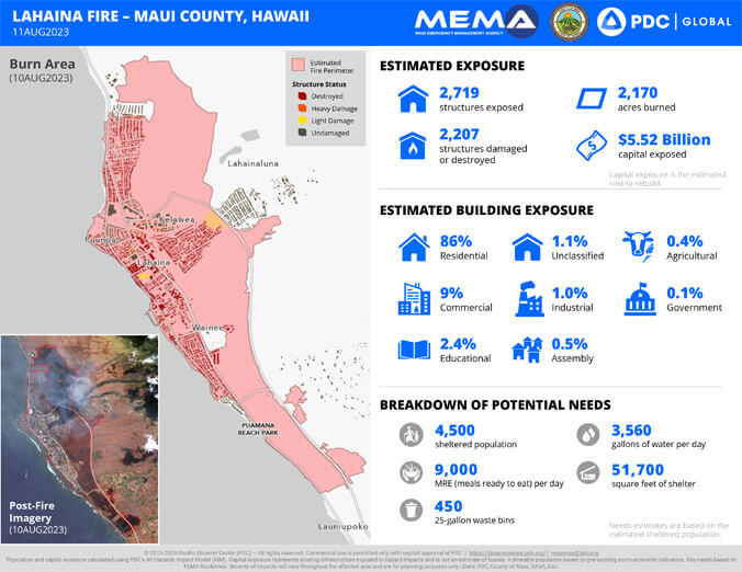
It will take an estimated $5.5 billion to rebuild from the Lahaina fire according to a Maui County release dated August 11, 2023.
The release was based on August 11 damage assessment maps of Lahaina and Kula by the University of Hawaiʻi’s Pacific Disaster Center (PDC) and the Maui Emergency Management Agency. Capital exposure estimates such as the $5.5 billion in Lahaina represent the total replacement value of all structures within the exposed hazard area. This value does not necessarily reflect all costs associated with reconstruction. However, these early estimates are useful for providing a better understanding of damages as most structures within the impact zone were almost completely destroyed.
The map shows the Lahaina fire resulted in an estimated total of 2,719 structures exposed; 2,207 structures damaged or destroyed; and 2,170 acres burned. According to the release, 86% of the buildings burned were residential.
In addition, the Lahaina map estimates 4,500 sheltered with needs for 9,000 meals and 3,560 gallons of water per day.
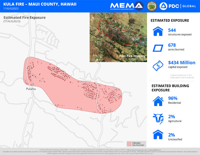
The Kula fire map shows an estimated $434 million cost to rebuild, with 678 acres burned and 544 structures exposed.
More on how to help Maui ʻohana and the Maui wildfires.
“First and foremost, our hearts and thoughts are with the victims of this immense tragedy. Our entire Maui ʻohana are grieving these losses. We commend the members of our community, the many volunteer organizations, and our first responders, many of whom have sacrificed everything and lost loved ones while in the line of duty, for their heroic efforts to save lives and relieve suffering,” said PDC Executive Director Ray Shirkhodai.
Shirkhodai explained that the damage and needs estimates released by PDC and its partners at the County of Maui Enterprise GIS Section and Maui Emergency Management Agency are designed to aid rapid response, planning and coordination between partners on the ground.
“As new and refined information become available to enhance understanding of the situation and humanitarian needs, it will be released through the County of Maui following thorough vetting for accuracy,” said Shirkhodai.